


The Rise of Drone Technology in Conservation
As a self-professed tech enthusiast, I’ve been fascinated by the rapid evolution of drone technology over the past decade. These unoccupied aerial vehicles (UAVs) have truly taken the world by storm, revolutionizing everything from filmmaking to scientific research. But perhaps one of the most exciting frontiers for drone technology lies in the realm of conservation and environmental monitoring.
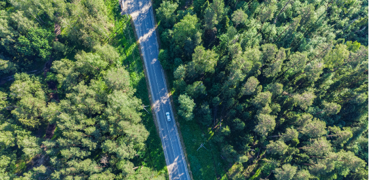
Just imagine soaring over a lush, biodiverse landscape, capturing stunning aerial footage and collecting valuable data on the health of the ecosystem. That’s the promise that drones hold for conservationists and researchers alike. By providing an affordable, flexible, and high-resolution means of surveying hard-to-reach areas, these flying robots are transforming the way we observe and understand the natural world.
Drones are increasingly used in conservation to manage and monitor biodiversity, offering a wealth of capabilities that were previously out of reach. From tracking the regeneration or degradation of forests to monitoring wildlife poaching and illegal timber extraction, these aerial platforms are proving to be invaluable tools in the fight to protect our planet’s precious ecosystems.
Pushing the Boundaries of Aerial Imaging
One of the most exciting aspects of drone technology is its ability to capture breathtaking aerial imagery that was once the exclusive domain of expensive, full-sized aircraft. By equipping these nimble UAVs with high-quality cameras and specialized sensors, conservationists can now obtain detailed, fine-grained data that was previously inaccessible.
Drones offer rich capabilities to observe in difficult terrain, allowing researchers to venture into areas that were once treacherous or even off-limits. Imagine the thrill of soaring over a remote, jungle-covered landscape to capture high-resolution footage of endangered species in their natural habitat. Or the invaluable insights that can be gleaned from meticulously mapping the regeneration of a forest after a devastating fire or storm.
But the capabilities of drone technology extend far beyond merely capturing stunning visuals. These aerial platforms can be outfitted with a wide array of specialized sensors, from multispectral cameras that can distinguish between different plant species to thermal imaging systems that can detect the presence of wildlife. The potential for using drones to gather detailed, real-time data on the state of our environment is simply staggering.
Revolutionizing Conservation Efforts
As the technology continues to evolve, drones are becoming increasingly accessible and affordable, opening up new frontiers for conservation efforts around the world. Drone Dudes, a pioneering company in the drone industry, has been at the forefront of this revolution, offering a wide range of advanced drone solutions tailored to the unique needs of conservation organizations.
Whether it’s capturing cinematic aerial footage to raise awareness about pressing environmental issues or deploying specialized sensor packages to monitor critical habitats, Drone Dudes has the expertise and the technology to help conservationists achieve their goals. And as the company continues to push the boundaries of what’s possible with drone technology, I can’t wait to see how the field of conservation will continue to evolve.
Of course, the introduction of drones into the conservation landscape is not without its challenges and considerations. There are important social and political implications to consider, such as concerns around privacy, data security, and power dynamics. Conservationists must be mindful of how these technologies can be perceived and used, and work to address any potential risks or unintended consequences.
Unlocking the Full Potential of Drones in Conservation
Despite these complexities, the transformative potential of drones in conservation is simply undeniable. By providing affordable, flexible, and high-resolution means of aerial data collection and monitoring, these remarkable flying machines are empowering researchers, policymakers, and community organizations to tackle some of the most pressing environmental challenges of our time.
As I reflect on the rapid evolution of drone technology, I’m struck by the sheer breadth of its applications. From mapping deforestation and tracking wildlife poaching to supporting disaster response efforts and engaging local communities, the possibilities seem endless. And with continued advancements in areas like sensor technology, autonomous flight, and data analytics, I can only imagine the incredible breakthroughs that lie ahead.
So, whether you’re a seasoned conservationist or simply someone who cares deeply about the health of our planet, I encourage you to keep a close eye on the cutting edge of drone technology. Because if there’s one thing I’ve learned, it’s that these aerial marvels are poised to transform the way we understand, protect, and restore our natural world.